Editor's note: This article was originally written in 2007 for the Waterfront Preservation Alliance of Greenpoint and Williamsburg. It has been revised and updated with new information, including information from the New York City Landmarks Preservation Fillmore Place Historic District Designation Report (2009).
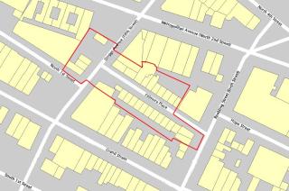
The proposed Fillmore Place Historic District is a rare example of a nearly intact collection of mid-19thcentury flat houses centering on a single historic real estate development. The block-long street that forms the core of the proposed district was carved out of the Williamsburgh street grid in 1852, and developed by Alfred Clock & Ephraim Miller over the course of the following four years. In addition to the Clock & Miller development, the proposed Fillmore Place Historic District includes five mid-19th-century residential and commercial buildings on Driggs Avenue. These buildings are of a similar period to the Fillmore Place buildings and form a gateway to the western end of the street.
The proposed Fillmore Place historic district is significant for its cohesive architecture, and its pattern of development, which, taken together, impart a deep sense of place to the block-long street. The Clock & Miller development is a unique collection of mid-19th-century flat houses and represents one of the largest intact developments of this period. In addition, the Fillmore Place Historic district is closely associated with author Henry Miller, who spent part of his childhood at 662 Driggs Avenue and wrote extensively about that “most enchanting street”1, Fillmore Place, and the surrounding neighborhood. Miller’s descriptions provide a vivid first-hand account of Fillmore Place and Williamsburg in the decade before the turn of the 20thcentury.
History and Geography of Williamsburgh
The area of Brooklyn that is today called Williamsburg (without an “h”) was, together with Greenpoint, in Colonial times part of the town of Bushwick. One of the five original Colonial-era towns of Kings County (together with Brooklyn, Flatbush, New Utrecht and Gravesend), Bushwick was first settled by French émigrés. The center of the Town of Bushwick, such as it was, was located about a mile east of Fillmore Place, near the intersection of what is now Metropolitan Avenue, Bushwick Avenue and Woodpoint Road.
Throughout the 17thand 18thcenturies, the portion of Bushwick that was to become Williamsburgh was sparsely populated. Primarily Dutch but also French, Swedish and English settlers established farmsteads throughout the area, with the village center remaining at Woodpoint Road. Farms passed down through local families such as the Meserole, Titus, Skillman, Provost, Wyckoff and Dunham.
In 1802, Richard Woodhull purchased the 13-acre Charles Titus farm, located on the Bushwick waterfront north of today’s Metropolitan Avenue. It was on this tract of land, bordered on the east by Bushwick Creek (roughly where Union Avenue runs today), that Woodhull proposed to establish a new village. In 1802, Woodhull hired Colonel Jonathan Williams to lay out the streets and avenues of his proposed development. It was in honor of Colonel Williams that Williamsburgh (with an “h”) got its name. To serve his new settlement, Woodhull established regular ferry service from Bushwick to Rivington Street in Manhattan. Woodhull’s ferry departed from the foot of the Jamaica Farm Road/Turnpike, which ran along of the course of today’s Metropolitan Avenue to Jamaica, Queens.
Two years later, Thomas Morrell purchased a 25-acre farm south of today’s Grand Street from Folkert Titus. Morrell proposed to establish a separate settlement following the same pattern of street, called Yorkton and set up his own ferry service from the foot of Grand Street to Grand Street in Manhattan. With time, both ventures would fail, and although Morrell’s lasted longer, it was Woodhull’s name that stuck.2
The original plan of the Village of Williamsburgh consisted of a rather confusing array of numbered streets running north to south (with First Street (now Kent Avenue) at the river and Eleventh Street (now Union Street) to the east) and numbered streets running east to west. Grand Street served as the dividing line between north and south, with the east/west street numbers increasing in each direction (North 1st, North 2nd, etc. and South 1st, South 2nd, etc.). Williams’ plan retained a few thoroughfares that existed prior to the establishment of Williamsburgh, most notably the Jamaica Turnpike (which was renamed North 2ndStreet in the Williams plan - it did not become Metropolitan Avenue until the early 20thCentury).
Because the Jamaica Turnpike did not follow a straight path to the east, North 2ndStreet carved an eccentric line through Williams’ otherwise rational grid. The curve of the Turnpike began between Fourth Street and Fifth Street (Bedford Avenue and Driggs Avenue today). This resulted in odd sized blocks between there and the Williamsburgh and Bushwick village border at Union Avenue.
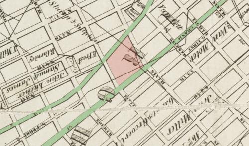
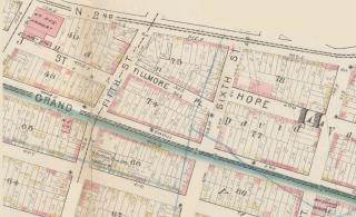
Fillmore Place was not part of the original Village of Williamsburgh, as laid out by Colonel Williams in 1802. North 1stStreet always terminated at Fifth Street (Driggs Avenue), while Hope Street to the east started at Sixth Street (Roebling Street) and continued east to the village border at Eleventh Street (Union Avenue).3 The block that was bounded by North 2ndStreet (Metropolitan Avenue) and Grand Street, Fifth Street (Driggs Avenue) and Sixth Street (Roebling Street), was thus very deep in its north/south dimensions.
In 1852 Clock & Miller filed a map with the Kings County Registrar’s Office to bisect this super block with a new east/west street to be named Fillmore Place. The earliest reference to Fillmore Place.4 The first public mention of the venture comes in an 1852 New York Timesarticle, which notes “Messrs. Clock and Miller have commenced opening, at their own expense, a new street, from South and Fifth-stret [sic], between Grand and North First. It will be built up with magnificent dwellings”.5 Many early public references (and residents) called it Fillmore Street.6
In the same year that Fillmore Place was established, Williamsburgh was declared a city in its own right. In the preceding decades, Williamsburgh had grown from a small village to a town separate from Bushwick, and then to a city. Along the way, the population of Williamsburgh had grown from 934 in 1820 to 1,117 in 1830 to 5,094 in 1840. By the time it was declared a city in 1852, the population of Williamsburgh was estimated at 38,000, making it one of the larger cities in New York State.7
Williamsburgh’s independence was short-lived, however. By 1854, the cities of Brooklyn and Williamsburgh were negotiating the annexation of the latter by the former. In 1855, the City of Brooklyn officially annexed the City of Williamsburgh along with the Towns of Bushwick and Greenpoint (it was at this point, for reasons unknown, that Williamsburgh officially lost its “h”).
Clock & Miller
Alfred Clock and Ephraim Miller were local merchants, real estate developers and prominent citizens of the Village of Williamsburgh. The two appear to have been active in Williamsburgh real estate as early as 1832, and by the 1850s were prominent citizens of the City of Williamsburgh.
Alfred Clock was born in Darien, Connecticut, in 1802.8 As early as 1832, he was in Williamsburgh investing in real estate. His daughter Eveline9married Jeremiah Meserole, thus marrying into one of Williamsburgh’s most prominent families. Together with Miller, Clock Sr. purchased at least one property from Jeremiah’s father, Abraham Meserole.
Although they sold most of the Fillmore Place properties soon after the new street was laid out, Clock & Miller held onto and rented out some properties into the late 1850s. The pair also owned properties at 86 North Second Street (now Metropolitan Avenue) and 189 Grand Street.
Patterns of Development and Ownership
Clock & Miller began acquiring the Fillmore properties in 1847 and appear to have completed acquisition by 1852. While the development concept (the master plan) and the cutting through of Fillmore Place appear to have been the work of Clock & Miller, not all of the properties where developed by the pair. The majority of the properties on the north side of the street were sold as vacant lots in 1852 and 1853, and the houses thereon were built at the same time by the purchasers. Clock & Miller were responsible for the development of many of the buildings, though, notably a block 9 houses on the south side of the street at 12 to 28 Fillmore Place. These and other Clock & Miller buildings were built by masons Jacob Sheppard and John Rourke. Clock & Miller retained ownership of most of the buildings that they constructed as income-producing properties.10
There were others who bought into the project for long-term investment purposes. Most of this latter class of buyers lived in the houses they purchased, for anywhere from 5 to 25 years. Buyers in this class, all of whom bought directly from Clock & Miller, include painter/paper hanger Enos Baker (10 and 24 Fillmore, 7 and 16 years respectively); joiner Thomas Coger (19 Fillmore, 20 years); and coppersmith Charles Heyman (170 Roebling, 31 years).11
All of the Fillmore Place buildings were occupied as multi-family residences, what were probably termed at the time flat houses (a class above the tenement, a term that was only coming into widespread usage in the 1850s). The patterns of ownership and occupancy in later years very closely match that of the surrounding area of Williamsburg. In the mid-19thcentury, most of the owners were English, Irish or German, and worked as artisans or were small merchants. The residents renting apartments on Fillmore Place at this time were of a similar background, usually artisans, clerks and laborers.
By the late 19th-century there was an increasing representation of Eastern Europeans among the owners and renters. These included Christian and Jewish Poles, Lithuanians, Estonians and Ukrainians. The Jewish residents were the separate from the wave of Jewish immigrants who moved from the Lower East Side in large numbers beginning in 1903, with the opening of the Williamsburg Bridge. From that point forward, much of the Southside and South Williamsburg came to be predominantly Jewish. Although the Williamsburg Bridge was certainly the catalyst for large number of Jews relocating to North Brooklyn, the Jewish population predated the construction of the bridge, as witnessed by the owners and residents of some of Fillmore Place buildings.12 Many of these earlier Jewish residents worked in the garment trades, as furriers, tailors and cutters.
The Christian immigrants from Eastern Europe tended to settle in the Northside, with Grand Street seeming to be the soft dividing line between what was becoming Baltic and Polish13 Williamsburg to the north and Eastern European and Russian Jewish Williamsburg to the south. Through 20thcentury, Fillmore Place continued to attract Baltic and Polish émigrés. Beginning in the 1930s, Hispanic names begin to appear in the conveyance and directory records, reflecting the influx of Puerto Rican transplants. Over time, Southside Williamsburg would become one of the largest centers of Puerto Ricans in New York City, a demographic heavily reflected in Fillmore Place.14
Throughout most of its history, the Fillmore Place houses have been a combination of owner-occupied and rental housing. Some of the houses were owned by absentee landlords and rented out entirely, while most were owner-occupied with portions of the houses rented out. In a few cases, the houses appear to have been entirely owner occupied.
Many of the Fillmore Place property owners owned multiple houses on the block. This was the case in the early years of development, when speculators bought multiple properties from Clock & Miller. In the late 19thcentury and early 20thcentury, William Dailey bought up numerous properties. On his death circa1929, Daily owned at least four houses on Fillmore Place.
Henry Miller
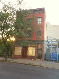
Author Henry Valentine Miller (Tropic of Cancer, Tropic of Capricorn) is closely associated with the Fillmore Place Historic District (but no relation to Ephraim Miller). Miller’s grandparents owned the house at 662 Driggs Avenue, facing the western end of Fillmore Place. This three-story flat house was constructed about 1867 by Joseph A. Goeller15,separately from Clock & Miller’s Fillmore Place development. In 1872, the house was purchased by Valentine Nieting, Henry Miller’s maternal grandfather (and presumably the source of the author’s middle name). Henry Miller was born to Heinrich & Louise Marie (Nieting) Miller on December 26, 1891. At the time of his birth, his parents lived in Manhattan’s Yorkville neighborhood (like Williamsburg, a heavily German enclave). Soon after the young Henry’s birth (“in the first year of my life”16), the Millers moved to 662 Driggs, where they lived until 1901.
Despite the rather short tenure on Driggs Avenue, Fillmore Place figured prominently in Miller’s Tropic of Capricornand was fondly recalled by him in an article he wrote for the New York Times in 1971. In that article, Miller described the physical environs of “this early Paradise”:
The house I lived in was between North First and Metropolitan Avenue, then called North Second Street… Diagonally opposite us was Fillmore Place, just one block long, which was my favorite street and which I can still see vividly if I close my eyes.
At the Driggs Avenue end of this street was a saloon and at the other end a kindergarten. I remember the saloon because as a child I was often sent to get a pitcher of beer at the side entrance; we called this `rushing the growler.’17
Of the surrounding neighborhood, Miller recalled:
Dividing North First Street from South First Street was Grand Street, a rather exciting street to us kids because [it was] full of stores of all kinds. The most outstanding of these was Reynolds Bakery, which even at that date, was already an institution. Mrs. Reynolds was undoubtedly the first woman I looked upon as a queen, or at least an aristocrat. She stood out above all the women I knew.
The back of the bakery gave out on North First Street, where we often played cat, or shinny as we called it then, and the aroma of fresh baked bread, crullers and doughnuts, assailed our nostrils day in and day out. On the other side of Grand Street was Daly’s Fish Market, which also stands out vividly in my memory, particularly the man Daly, who was very swarthy and hairy and, in my mind at least, seemed always to be opening oysters....18
Miller also described “the shanties, two or three decrepit buildings right out of a Dickens novel”. In one of these shanties lived the Meinken sisters, who operated a candy store.19
In Tropic of Capricorn, Miller refers to “the little neighborhood in Brooklyn which meant so much to me and from which I had been torn away too soon”.20 He describes Fillmore Place:
It was the most enchanting street I have ever seen in all my life. It was the ideal street – for a boy, a lover, a maniac, a drunkard, a crook, a lecher, a thug, an astronomer, a musician, a poet, a tailor, a shoemaker, a politician. In fact this is just the sort of street it was, containing just such representative of the human race, each one a world unto himself and all living together harmoniously and inharmoniously, but together, a solid corporation, a close knit human spore which would not disintegrate unless the street itself disintegrated.21
Miller’s description of the residents of Fillmore Place is remarkably accurate, with the possible exception of the politician. Elsewhere in Tropic of CapricornMiller describes in great detail Carl Ragner, “the only son of a politician who lived on the rather distinguished little street called Fillmore Place”.22 However, to date no record of such a person has been found, on Fillmore Place or elsewhere in the neighborhood.
Description
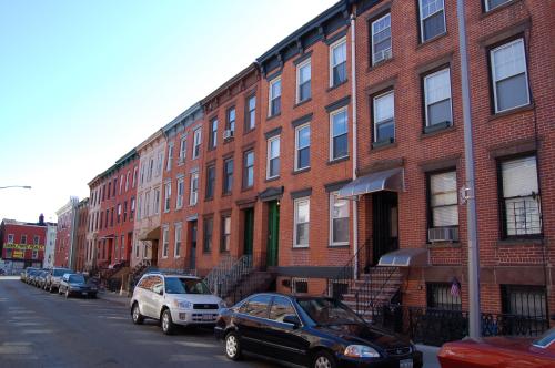
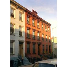
The buildings along Fillmore Place are typical mid-19thcentury brick flat houses, intended for middle-class merchants and working-class artisans alike. Most of the buildings are three-stories tall with a raised basement and a short stoop of four to six steps. The buildings have simple brownstone decoration and wood cornices; the most elaborate treatment is reserved for the front entries. There, articulated brownstone door hoods and wood door enframements distinguish one building from the next. The buildings fronting on Driggs Avenue and Roebling Street had storefronts at the ground floor, the remainder of the buildings were residential throughout. The buildings along the west side of Driggs Avenue are of a similar style and period to the Fillmore Place buildings but were not developed by Clock & Miller.
- 1Henry Miller, Tropic of Capricorn, [edition unknown], 215.
- 2The history in the preceding paragraphs has been largely drawn from Eugene Armbruster, Brooklyn’s Eastern District(Brooklyn: Privately Published, 1942), pp. 1 - 3.
- 3Hope Street appears on some early maps as North Street and has been noted on one map as North 1stStreet. This latter map may have been in error.
- 4An 1868 article in the Brooklyn Eaglereferences a “map of 37 lots belonging to Clock & Miller, and filed in the Kings County Registrar’s Office, in the year 1852...” [Eagle, 17 Dec 1868, “The City of Brooklyn - Edward McNamara against Jacob Shephard and John Rourke”]
- 5“Williamsburgh City,” New York Times, June 25, 1852, 2.
- 6See, e.g., “Williamsburgh News: Williamsburgh Election Riot,” Brooklyn Daily Eagle, November 18, 1854.
- 7Armbruster, 6.
- 8“Obituary Notes,” New York Times, May 2, 1887.
- 9Also referred to as “Emeline”.
- 10Conveyance information from index books located in Kings County Clerk’s Office. Employment information from Hearne’s Brooklyn City Directory(1859), located online at http://www.bklyn-genealogy-info.com/Directory/1859/index.html. This paragraph was updated based on the LPC Designation Report (“Fillmore Place Historic District Designation Report” (New York, N.Y.: New York City Landmarks Preservation Commission, May 12, 2009)), which straightened out much of the early conveyance history of the properties, and clarifies Clock’s & Miller’s roles as developers.
- 11Hearne’s Brooklyn City Directory(Brooklyn, N.Y.: Henry R. and William J. Hearne, 1859), http://bklyn-genealogy-info.stevemorse.org/Directory/1859/index.html.
- 12“United States Census, 1900” (National Archives and Records Administration, 1900), https://www.ancestry.com. Henry Miller [source?] also talks about the large number of Jewish residents on the Southside in the period before the construction of the bridge. Miller also mentions the construction of the bridge and subsequent influx of Jewish residents as a catalyst for his family’s move to Bushwick. However, the Millers moved to Bushwick in 1901, two years before the bridge was completed.
- 13It should be remembered here that the borders between Poland, the Ukraine, Belarus and the Baltic countries were constantly shifting. Therefore, many ethic Poles were identified (or self-identified) as from Russia, the Baltic countries, etc., and vice versa.
- 14One of the major impetuses for the movement of Puerto Ricans to New York City was the displacement of tenant farmers on the island that came about as a result of American Sugar and other sugar refining companies buying up large tracts of land and turning them over to sugar cane. Ironically, many of these displaced farmers wound up on the Southside working at the American Sugar’s Kent Avenue refinery, one of the largest sugar refineries in the world.
- 15“Fillmore Place Historic District Designation Report” (New York, N.Y.: New York City Landmarks Preservation Commission, May 12, 2009), 17.
- 16Henry Miller, “A Boyhood View of the Nineties,” The New York Times, October 17, 1971, A1.
- 17Henry Miller, “A Boyhood View of the Nineties,” The New York Times, October 17, 1971, A1.
- 18Henry Miller, “A Boyhood View of the Nineties,” The New York Times, October 17, 1971, A12.
- 19Henry Miller, “A Boyhood View of the Nineties,” The New York Times, October 17, 1971, sec. Archives.
- 20Henry Miller, Tropic of Capricorn, n.d., 214.
- 21Henry Miller, Tropic of Capricorn, n.d., 215.
- 22Henry Miller, Tropic of Capricorn, n.d., 142.
